
Hunter Creek Prescribed Burn
Basic Details
When will the burn take place?
The project will be implemented when conditions are ideal for a safe and effective prescribed fire. Conditions are considered suitable when the snow has sufficiently melted off the targeted areas and other surrounding areas still retain moisture and snow. These conditions typically occur in April or early May. Other environmental factors such as wind, temperature, and relative humidity are key elements to a successful controlled ignition. If conditions are not favorable, the project will be delayed.
How long will the burn take
Ignition will take place over a 1-3 day period. During this time, ignition operations typically last 4- 6 hours per day. Once ignition operations cease, crews will remain to monitor and contain fire spread.
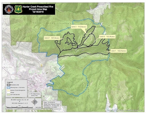
Where will the prescribed burn happen?
See the map. Prescribed fire will be ignited across approximately 1,100 acres in targeted blocks of aspen and mixed mountain shrub vegetation that is decadent, of poor condition, and degraded forage value.
Frequently Asked Questions
What should I expect during the prescribed fire?
On the days of the burn please do not call 911 if you see flames or smoke in this area. There may be large volumes of smoke visible at times, and people may even see flames. You can expect to see fire engines, crews, and possibly a helicopter over the fire. Signs and personnel will be posted for public safety. Little to no fire will be visible overnight.
What about the smoke?
Prior to burning, a smoke permit is obtained through the State of Colorado, Air Pollution Control Division. A project objective is to minimize smoke impacts on surrounding communities. Smoke may be seen from nearby communities and roads. Smoke should dissipate during the day but may remain on the valley floors as temperatures drop.
If you have a smoke sensitivity, please contact Dan Nielsen at 970-309-8198 so that we can keep you informed of smoke conditions. Prescribed fire smoke may affect your health. For more information, please visit: https://www.colorado.gov/pacific/cdphe/wood-smoke-and-health.
Can I fly my drone to see the fire?
Drones are illegal around fire operations. They are a threat to firefighter and public safety. NO Drone Zone.
Wasn't there a prescribed fire in Hunter Creek in 2016?
Yes - about 900 acres were burned. Five to ten years after a prescribed fire, it is very common to come back and burn the same area again. This practice is referred to as re-entry. There are a number of reasons for re-entries including: burning units that weren’t burned during the initial fire, reburning areas that burned very mildly during the first fire, and maintaining areas opened up by the initial burn.
Alerts
Where can I get more information and sign up for alerts?
- White River National Forest Facebook page at Facebook @WhiteRiverNF.
- Contact the Aspen-Sopris Ranger District at (970) 963-2266
Sign up for alerts:
- Pitkin County Alert System: Information will be disseminated via the Pitkin Alert system. To sign up for the alert system visit www.PitkinAlert.org.
- Garfield County: http://garco911.org/.
- Eagle County: Eagle County - Citizen Alert - Sign In (everbridge.net)
“We will only ignite during conditions that allow us to maintain control of the prescribed fire. We monitor weather and fuels to meet resource objectives with these burns, and we strive for good smoke dispersal to minimize impacts to nearby communities,” said Lathan Johnson, UCR Assistant Fire Management Officer.
The prescribed burn is part of the Hunter Creek Smuggler Mountain Cooperative Plan. Fire managers have developed a detailed prescribed fire plan and obtained smoke permits from the State of Colorado.
Special thanks to the following organizations for participation and collaboration:
- USFS White River National Forest
- City of Aspen
- Pitkin County
- Aspen Fire Protection District
- Aspen Center for Environmental Studies
- Wilderness Workshop
- Roaring Fork Outdoor Volunteers
- Roaring Fork Mountain Bike Association